The view is worth the ascent
- 5:40 h
- 10.14 km
- 1,500 m
- 439 m
- 581 m
- 1,719 m
- 1,138 m
- Start: Oberried
- Destination: Planalp (Rothorn railway)
The start is tough: On a steep zigzag path, an altitude difference of 1000 meters is almost entirely overcome in the mountain forest. At the location Spichern, a small hut with benches offers space for a rest. Here the forest begins to thin out and reveals first views down onto the turquoise shimmering Lake Brienz. A last steep ascent across a sun-exposed grassy slope leads to Bitschi, a small and flat hill promontory on the steep flank of the Tannhorn. In bad weather, a small hut provides shelter from storm and rain. In good visibility, the view wanders from Morgenberghorn above the "Bödeli" to the peaks of Eiger, Mönch, and Jungfrau, which are visible behind the Faulhorn chain; further east the Haslital and Hasliberg are shown, behind them the first Inner Swiss peaks can be made out.
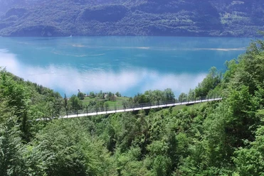
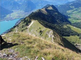
From Bitschi a mountain hiking route branches off with further ascent to the Ällgäulücke and from there down to Kemmeribodenbad (2 h 45). Towards Planalp it goes eastwards. The route runs at almost constant height along the slope initially to Rotschalp. On the way, with some luck, numerous chamois and ibex can be seen grazing often not far from the path. Like a magic mirror lies the blue-green shimmering surface of Lake Brienz in the depth.
From Rotschalp a forest road leads down to Planalp. From there there are several descent options towards Brienz (between 1 h 30 and 2 h 15). But the most attractive end to the tour is a nostalgic train ride with the steam-powered Brienz-Rothorn railway down to Brienz. Attention: the operation of the railway is stopped at the end of October each year; in case of large crowds, longer waiting times have to be accepted at the intermediate station Planalp.

Good to know
Pavements
Best to visit
Directions
Oberried - Bitschi - Rotschalp - Planalp (Brienzer Rothorn Railway)
Equipment
We recommend the following equipment: sturdy mountain boots, medium-sized backpack with hip belt, sun protection, rainwear, hiking poles, first aid kit, picnic, enough fluids, mobile phone.
Directions & Parking facilities
Outbound: by train via Interlaken Ost to Oberried.
Return: from Planalp with the Brienz Rothorn railway to Brienz.
Additional information
Association of Bernese Hiking Trails, Bern, Tel.: 031 340 01 01, Email: info@beww.ch, Homepage: www.bernerwanderwege.ch
License (master data)
Safety guidelines
This route runs entirely or partially on mountain hiking trails.
Map
Swisstopo hiking map 1:50,000 254T Interlaken
Nearby


")
