Opposite the ice-armored Jungfrau


- 4:15 h
- 8.46 km
- 900 m
- 700 m
- 1,231 m
- 2,017 m
- 786 m
- Start: Mürren
- Destination: Obersteinberg
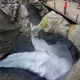
From Mürren train station you pass through the village along the lower street and descend to Gimmelwald (50 min to Wasserbrigg–Stechelberg; 2h30 to Wasserbrigg–Pfäffer–Obersteinberg). In old chronicles, the village is mentioned as a Walser settlement. The view of the massive rock and ice falls at Schwarzmönch and Jungfrau is captivating. Now you go down into the Sefinental. Noteworthy are the erosions of the Schiltbach, which you cross roughly halfway along the path.
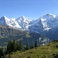
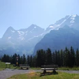
In the valley, you immediately turn downstream and cross the Sefinen Lütschine on a bridge at the next opportunity. The well-constructed mountain path overcomes a rock band extending over more than 2 km along the valley flank. Above this, the incline even increases. Only above the tree line at Alp Busen is there a short rest. Swiss stone pines give the area a special character. The path towards Obersteinberg also passes Swiss stone pines as it ascends to the ridge between the Sefinen and Lauterbrunnen valleys (point 1978). The view downstream into the basin of the farthest Lauterbrunnen valley is breathtaking! Even more beautiful is the view a bit further above on the terrace of Tanzbödeli, which can be reached on a short, steep side path. To the north, you overlook the Lauterbrunnen valley up to the Männlichen ridge; to the south stands the massive circle of snow-covered mountains with their glaciers and torrents. This is one of the most impressive spots that mountain hikers can visit in the Alps.
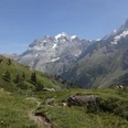
The descent to Obersteinberg first leads back to point 1978 and then along a steep grassy slope. The path is partly rocky, so caution is necessary! The view from the hotel terrace also leaves nothing to be desired: numerous wild waters and glacial streams roar far below, while hanging glaciers shimmer on the mountain slopes between Jungfrau and Tschingelhorn (2h10 from Pfäffer–Gimmelwald; 1h40 from Trachsellauenen–Stechelberg).

Good to know
Pavements
Best to visit
Directions
Mürren - Gimmelwald - Sefinental - Tanzbödeli - Obersteinberg (overnight stay)
Equipment
We recommend the following equipment: sturdy mountain boots, medium-sized backpack with hip belt, sun protection, rainwear, hiking poles, pocket first aid kit, picnic, sufficient fluids, mobile phone.
Directions & Parking facilities
Getting there: by train via Interlaken Ost to Lauterbrunnen. Then by gondola to Grütschalp and further by train to Mürren.
Additional information
Association of Bernese Hiking Trails, Bern, Tel.: 031 340 01 01, Email: info@beww.ch, Website: www.bernerwanderwege.ch
Literature
Hiking suggestion from the Jungfrau Region Brienzersee - Oberhasli hiking book series of the Bernese Hiking Trails
License (master data)
Safety guidelines
This route runs wholly or partially on marked paths of the mountain hiking trail category.
Map
Swisstopo hiking map 1:50,000 264T Jungfrau
Nearby


")