- 4:00 h
- 9.34 km
- 1,000 m
- 450 m
- 893 m
- 1,609 m
- 716 m
- Start: Burglauenen
- Destination: Wengen
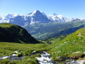
The northern slope of the Männlichen is steep and rugged. Steep avalanche tracks and dense mountain forest dominate the terrain. But there are also alpine pastures here. Powerful masses of snow thunder down in winter. In spring they remain for a long time, which gave the pasture its name “Spätene”. It is not advised to do the route before the end of June because snow and ice still lie in the ravines. At Burglauenen station, the cantonal road and the Black Lütschine are crossed. The route initially runs on a paved lane, which after about one kilometer becomes a gravel path and later a forest path. The rather steep ascent goes through mountain forest past isolated barns and huts via Ritten to the Spätenenalp. At the alpine hut there is a small inn with drinks and snacks. A wide gravel path leads with gentle inclination over alpine pastures and through forest to the Leiterhorn viewpoint. The moment when you leave the forest and unexpectedly open up the view of the vast and magnificent mountain world of the Lauterbrunnen valley represents a key experience of this hike. From the Leiterhorn viewpoint, you enjoy probably the richest and most splendid view of the valley of the White Lütschine. The descent to Wengen runs on gravel paths, and on paved lanes in the settlement area.

Pavements
- Asphalt (9%)Trail (49%)Path (41%)
Best to visit
- suitableDepends on weather
Directions
- Burglauenen - Spätenalp - Leiterhorn - Wengen
Equipment
- We recommend the following equipment: sturdy mountain boots, medium-sized backpack with hip belt, sun protection, rainwear, hiking poles, first aid kit, picnic, sufficient fluids.
Additional information
- Association Berner Wanderwege, Bern, Tel.: 031 340 01 01, E-mail: info@beww.ch, homepage: www.bernerwanderwege.ch
License (master data)
Safety guidelines
- This route runs entirely or partly on mountain hiking trails.
Map
- Swisstopo hiking map 1:50,000 254T Interlaken