The wild romantic Suldtal valley


- 4:45 h
- 13.51 km
- 690 m
- 1,010 m
- 692 m
- 1,588 m
- 896 m
- Start: Aeschiried/Schulhaus
- Destination: Mülenen
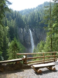
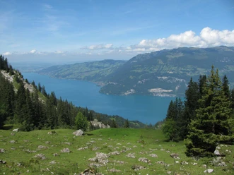
From the starting point in Aeschiried, follow the signs towards Brunni. After just 300 meters, you are on a hiking trail that changes into a white-red-white marked mountain hiking trail at Aeschi-Allmi. This also marks the beginning of the ridge trail, which leads via Greberegg to the Brunnihütte. On the right – in the direction of the hike – you can see the southern Suldtal valley; on the left, you can repeatedly catch views of Lake Thun. Behind you is the Niesen, ahead rises the Morgenberghorn. After crossing the grassy summit of Greberegg, a signposted and direct path branches off right to Suld. Here you leave the ridge and steeply descend through the Hindere Leimere forest to the Suld inn with its beautiful sun terrace – not far from the 81-meter high Pochtefall waterfall, which can be reached in about 15 minutes. Then follows a peaceful, natural, almost flat section along the Suld stream. The yellow-marked path leading downstream runs first to the left of the stream, then to the right. From the Staldeweid junction, the path is marked white-red-white, which means that the narrow trail often has short but somewhat steeper sections both uphill and downhill. At the Suldhaltenstrasse junction, keep left and follow the now yellow-marked hiking path down to the Suld. Along the stream, the path finally continues on a small road to Mülenen station.
Background: The Suld inn has been a summer restaurant since 1914. Electricity came from a water wheel starting in 1925, which still supplies energy for its own use today. The inn is located in the Suldtal nature reserve, which covers almost the entire length of the valley of the same name and is flanked by the peaks of Morgenberghorn, Dreispitz, and Schwalmere.

Good to know
Pavements
Best to visit
Directions
Aeschiried – Greberegg – Suld – Staldeweid – Mülenen
Equipment
We recommend the following equipment: sturdy hiking boots, medium-sized backpack with hip belt, sun protection, rain gear, hiking poles, first aid kit, picnic, sufficient fluids, mobile phone.
Directions & Parking facilities
Return trip: by train from Mülenen
Additional information
Literature
License (master data)
Author´s Tip / Recommendation of the author
Safety guidelines
Map
Nearby

")
