Springenboden Trail - Diemtigtal (signposted)


- 3:00 h
- 5.47 km
- 380 m
- 380 m
- 1,326 m
- 1,658 m
- 332 m
- Start: Gsässweid, Springenboden
- Destination: Gsässweid, Springenboden
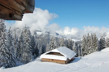
Signposted snowshoe tour (circular hike) on the sunny terrace of the Diemtigtal Nature Park. The starting points of the 5.6-kilometer-long snowshoe route (circular hike) are the two restaurants Gsässweid and Springeboden. The path is signposted, but the trail is made by the snowshoers themselves. After the ascent, the Alp "Otteschwand" offers a first impressive view into the rear Diemtigtal and Simmental. From the highest point Nüjestift, the descent leads over snowy alpine meadows past isolated alpine huts and large mountain maples. The distinctive trees, with a little imagination, look like giant snow sculptures. Back at the parking lot, snowshoers like to warm up with a hot drink in one of the mountain inns.

Good to know
Pavements
- Street (2%)Asphalt (16%)Trail (39%)Unknown (43%)
Best to visit
- suitableDepends on weather
Directions
- Gsässweid - Otteschwand - Wildmoos - Nüjestift - Gsässweid
Equipment
- We recommend the following equipment: sturdy and waterproof mountain boots, light to medium backpack, cold protection, sun protection, hiking poles, first aid kit, snacks, tea in a thermos bottle, mobile phone.
Directions & Parking facilities
- Public transportationArrival and return: by train via Spiez to Oey-Diemtigen. Then by bus to Horboden, Chirel.
From Horboden, Chirel, the SchneeTouren bus runs to Springeboden. The bus must be reserved!
Detailed timetable at:
https://schneetourenbus.ch/strecken/horboden-springenboden-diemtigtal
Additional information
Association Berner Wanderwege, Bern, Tel.: 031 340 01 01, Email: info@beww.ch, Homepage: www.bernerwanderwege.ch
License (master data)
Safety guidelines
- This route is marked as a snowshoe route but is not specially prepared.
Map
- Swisstopo topographic map 1227 Niesen 1:25,000
Nearby


Download GPX file