In the sign of the Saane


- 4:10 h
- 10.52 km
- 1,010 m
- 130 m
- 1,174 m
- 2,061 m
- 887 m
- Start: Gsteig b. Gstaad / Post
- Destination: Sanetsch
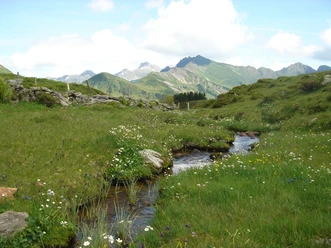
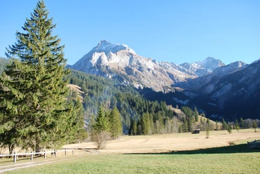
From the bus stop in Gsteig, take the shortest route to the Saane – crossing the Rüschbach, turning left and just 500 meters later this flows into the Saane. Go right and the path then runs directly along the bank to the valley station of the Sanetsch cable car, against the flow direction. After that, it goes steeply uphill along the roaring Saane to Rotegrabe. A large rockfall from the west flank of the Spitzhorn destroyed the historic mule track here in 2017. Since further rock falls were not excluded, the hiking trail was relocated. Today, the Rotegrabe is crossed by a new bridge, leading to the path inaugurated in 2019, before shortly returning to the original trail. The route leads out of the forest and up numerous switchbacks. A magnificent view opens towards Gsteig. Just before the end of the ascent, you pass the cantonal border and now hike on the Valais side to Lake Sanetsch, fed by the Saane. Even though you can turn directly right at the Barrage du Sanetsch junction to the Sanetsch reservoir mountain station, the one-hour circuit of the reservoir is worthwhile. You follow the trail left to the eastern shore of the lake up to the southern bridge, over which you cross the still small Sarine stream. On the west side, the trail snakes through large boulders that have tumbled down from the Mountons cliffs. Over the dam at the north end, you reach the Auberge du Sanetsch, inviting a stop. From here, there is a wonderful view of the impressive rock faces around Arpelihore and the over 3000-meter-high Arpelistock. The endpoint is the mountain station of the Sanetsch cable car.
Background: The dam was built between 1959 and 1966 in two stages. Energy production began in 1963 after the reservoir was built. The passenger cable car started operation in 1989.

Good to know
Pavements
Best to visit
Directions
Equipment
We recommend the following equipment: sturdy mountain boots, medium-sized backpack with hip belt, sun protection, rain gear, hiking poles, first aid kit, picnic, enough fluids, mobile phone.
Directions & Parking facilities
Return: by Sanetsch cable car to the valley station (ticket reservation recommended), then on foot (20 min) to the stop Gsteig b. Gstaad / Post
Additional information
Literature
License (master data)
Author´s Tip / Recommendation of the author
Safety guidelines
Map
Nearby
