Over the Sanetsch Pass into Valais


- 4:50 h
- 12.15 km
- 1,300 m
- 145 m
- 1,178 m
- 2,243 m
- 1,065 m
- Start: Gsteig
- Destination: Hôtel du Sanetsch
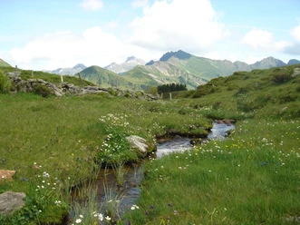
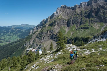
From the center of Gsteig, along Innersteigstrasse across the valley floor to the already impressive Saane river at Innergsteig, past the power plant to the valley station of the Sanetsch-Bahn. Now the ascent begins. Before the large stone at point 1478 – a witness of the 1946 earthquake – (to Burg–Gsteig 1h; to Walliser Wispile–Chrine–Gsteig 3h45; and –Chrine–Louwenesee 3h10, both mountain hiking trails) the pass path winds in many zigzag turns through the steep, rock-lined basin of Gaagge up to the canton border. At 2002 m above sea level you enter Valais territory. The view into the valley and the beautifully green pre-Alpine landscape of the Saanenland is very impressive. Cars on the Pillon road look like small beetles. A forest road leads across the wide floor of Sénin past the cable car station, chapel, and mountain lodge to Lac de Sénin (Sanetsch lake). Over the dam crest to the pass road, on which a post bus service runs from Sion in summer. However, the pass summit lies more than an hour further south. The historic pack trail lies here under the reservoir, which is bypassed on a well-maintained path. Weathered rock blocks lie like ruins along the road in the meadows of Sénin. Dark Eringer cattle and large flocks of sheep enliven the wide high valley. Through a gorge-like ravine, the Sarine (Saane) flows toward the reservoir. At Chalet de la Crêta, the pack trail briefly touches the pass road winding upwards in hairpin bends and almost effortlessly gains the height of the Col du Sanetsch, passing an old wooden cross. To the right of the path lie extensive karst fields stretching for kilometers to the Tsanfleuron glacier. To the left the Arête de l’Arpille leads to Arpelistock, and to the south, beyond the Rhone valley, gleam the peaks of the Valais high Alps. From the lush green plain of Alp Tsanfleuron (= "flower-covered meadow") you reach, by a steep section, the former, well-known for its mountain views, Hôtel du Sanetsch.

Good to know
Pavements
Best to visit
Directions
Equipment
Directions & Parking facilities
Outbound journey: By train to Gstaad. Then by bus to Gsteig.
Return journey: From Hotel Sanetsch by bus to Sion.
Additional information
Literature
Hike suggestion from the Simmental - Saanenland hiking book, hiking book series of the Berner Wanderwege
License (master data)
Safety guidelines
This route runs wholly or partially on marked paths of the mountain hiking trail category.
Map
Swisstopo hiking map 1:50,000 263T Wildstrubel
Nearby
