High-altitude trail with a summit above Hasliberg


- 4:50 h
- 15.64 km
- 470 m
- 1,270 m
- 1,422 m
- 2,245 m
- 823 m
- Start: Flat Plates
- Destination: Bidmi
Anyone strolling through Meiringen will notice that the village is dominated by stone houses. Devastating fires had struck the village several times, and after the severe fire of 1891, only stone was permitted for construction. The marshy valley floor of the Oberhasli had been regularly flooded. It wasn’t until the second half of the 19th century, when the water level of Lake Brienz was lowered, that the area could be drained. Not least because of these fires and floods, great poverty prevailed in Meiringen 150 years ago. An unusual source of income was silk weaving, which some families used to supplement their meager earnings. On the Hasliberg as well, silk weaving provided a small supplementary income alongside agriculture. In addition, iron ore had been mined at Planplatten and on the Hohsträss since the 14th century. On the national map, one can still find the entry “Erzgrueben” (ore mines) northeast of Planplatten. This ore was transported to the Gental valley, where a blast furnace was in operation until the early 19th century.
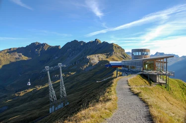
Our hike also begins at Planplatten. To get in the mood, walk past the Alpen Tower restaurant to the Planplatten lookout point, where you’ll be captivated by the entire panorama dominated by the Wetterhorn range. The return route follows the high-altitude trail toward Hääggen. This sunny alpine inn, with its friendly Bernese Mountain Dog, is extremely inviting. The trail climbs slightly again and then leads through the pretty Jüchli-Täli valley down to Käserstatt. From there, it’s a gentle climb back up to the Gibel, an unassuming peak offering wonderful panoramic views and vistas of the Brienz and Lungern lakes. The descent first leads to Balisalp—which can also be reached directly from Käserstatt via a shorter route—and then through secluded forests and moorlands to Bidmi, where a lake, playgrounds, restaurants, and the gondola await.
Text: Fredy Joss

Good to know
Pavements
- Path (61%)Trail (34%)Asphalt (5%)
Best to visit
- suitableDepends on weather
Directions
- Planplatten – Hääggen – Käserstatt – Gibel – Balisalp (Vordere Stafel) – Lischen – Bidmi
Equipment
- We recommend the following gear: Sturdy hiking boots, a medium-sized backpack with a hip belt, sunscreen, rain gear, hiking poles, a first-aid kit, a picnic lunch, plenty of water, and a cell phone.
Directions & Parking facilities
- Public transportationGetting there: Take the train to Meiringen, then walk to the Meiringen-Hasliberg cable car; from there, take the cable cars via Hasliberg, Reuti, Bidmi, and Mägisalp to Planplatten
Return trip: Take the gondola lifts from Bidmi to Meiringen, then walk to the train station
Additional information
- Bern Hiking Trails, 031 340 01 01, info@beww.ch, bernerwanderwege.ch
License (master data)
Author´s Tip / Recommendation of the author
- From Käserstatt, you can hike directly to Balisalp. The hike is shorter, at 10.9 km and 3 hours 15 minutes.
Places to stop for a bite:
- Alpen Tower Panorama Restaurant, Planplatten
- Häägenstubeli (open only in winter)
- Käserstatt Mountain Restaurant
- Balis Alpine Restaurant (by reservation only for groups of 15 or more)
- Bärgbeizli Bidmi Safety guidelines
- This route follows, either entirely or in part, marked trails classified as mountain hiking trails.
Map
- swisstopo Hiking Map: 255 T Susten Pass, 1:50,000