- 1:40 h
- 6.29 km
- 174 m
- 779 m
- 953 m
- 174 m
- Start: Frutigen, Rohrbach
- Destination: Frutigen, station
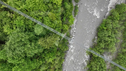
Findings suggest that the area was already settled during the Bronze and Roman periods. The first documented mention dates from 1234. The website of the Frutigen community promises that you can combine tranquility and activity here according to your own needs. This is also promised by the following suggestion for an effortless and relaxing route. At the starting point of the hike at the Frutigen Rohrbach bus stop, the signpost points to Frutigen. The route is therefore easy to find. A short steep descent on a footpath leads down to the Entschlige. Its soothing murmur accompanies the hikers to the village of Frutigen. A sign announces that a floodplain area of national importance is located here. Now the route alternates between forest and gently downhill directly along the Entschlige – except for some uphill sections – towards Frutigen. On smaller suspension bridges, you cross the Gempelegraben and Zwüschebachgrabe. At Hohstalden, the namesake suspension bridge crosses the Entschlige valley and the hiking trail. The view from the unusual perspective from below on the impressive, delicate structure is impressive. At the time of its opening in 2006, it was one of the longest in Europe with a length of 153 meters. After the Grantibrügg, the valley floor widens. Opposite the campsite, you cross the last suspension bridge. The footpath then turns into a neighborhood street. Soon, the Kanderstegstrasse and the Entschlige must be crossed. Passing a playground, you reach the end of the hike at Frutigen station.

Pavements
- Street (12%)Trail (88%)
Best to visit
- suitableDepends on weather
Directions
- Rohrbach – Hohstalden - Grantibrügg - Frutigen
Equipment
- We recommend the following equipment: lightweight trekking shoes, light backpack, sun protection, rain jacket, pocket first aid kit, light picnic, sufficient fluids, mobile phone.
Directions & Parking facilities
- Public transportation
Outbound: By train to Frutigen and then by bus to Frutigen Rohrbach
Return: By train from Frutigen
Additional information
- Bernese Hiking Trails Association, Bern, Tel.: 031 340 01 01, E-Mail: info@beww.ch, Homepage: www.bernerwanderwege.ch
Literature
Short hikes guidebook 2 by the Bernese Hiking Trails, order at: https://www.wanderplaner.ch/sommer/web-shop/
License (master data)
Safety guidelines
- This route runs exclusively on signposted hiking trails.
Map
Swisstopo hiking map 253T Gantrisch & 263T Wildstrubel 1:50,000, order at: https://www.wanderplaner.ch/sommer/web-shop/