Over Hugeli and Rellerligrat


- 4:45 h
- 15.13 km
- 846 m
- 846 m
- 1,222 m
- 1,861 m
- 639 m
- Start: Schönried
- Destination: Schönried
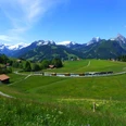
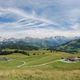
Thanks to its sunny altitude and early development by road and Montreux-Oberland Railway (MOB), Schönried quickly became a popular holiday resort. From the station, cross the main road and follow the small stream uphill to the houses on the Hubel. The little road gently climbs towards Bergmatte/Sumeli (15 min to Saanenmöser; 1h30 via Grossi Vorschess to the Rellerligrat) and later winds into the wooded Simnegrabe. Along the way, the view opens across the valley of the Kleine Simme and over the flank of the Rinderberg to the Spillgerte group. At Simne, the alpine road crosses to the other side of the valley, moves further away from the young Kleine Simme, and finally climbs steeply with many switchbacks up to the Bire hut. At the sizable alpine hut, in clear weather, the broad massif of the Grand Combin in the Valais Alps is visible above the Sanetsch Pass. Now the route swings westwards with slight ups and downs into the southern flank of the Schneitgrat and passes the huts of Vorderi Schneit, first descending gently, then slightly ascending to the foot of the Planihubel. Bypass this on its west flank and head through forest to Pt. 1806 (1h15 from Grossi Vorschess–Saanenmöser). The gentle climb to the Hugeligrat, the highest point of the hike, once again offers a magnificent panoramic view of the Pre-Alpine and High Alpine world of the Saanenland. Soon the forelying summit of the Rellerligrat (1h20 from Grossi Vorschess–Saanenmöser; 1h from Hugeli–Schönried) is reached, with the mountain station of the gondola from Schönried. For the especially adventurous, a 620 m long summer toboggan run is even available in good weather. Next, descend the steep ridge to the Rittmal alpine hut, where a medieval watchtower (a so-called Chutz) stood, relaying fire signals in case of danger from Flüeweid near St. Stephan to Rougemont and Château-d’Œx. In zigzags, descend steeply over the eastern flank of the Rellerligrat to Gspan (1h to Saanen). The comprehensive view of the Saanenland mountains enchants also on the further descent to Grüebli. Now the alpine path swings east into the Burrisgrabe and gently descends to Schönried.

Good to know
Pavements
Best to visit
Directions
Equipment
Additional information
Literature
License (master data)
Safety guidelines
Map
Nearby