Opposite the Engelhörner


- 5:40 h
- 16.79 km
- 670 m
- 1,290 m
- 589 m
- 1,874 m
- 1,285 m
- Start: Chaltebrunnen
- Destination: Meiringen
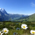
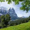
From the Chaltenbrunnen post bus stop, walk briefly downhill into the valley, then over the Rychenbach and on a wide alpine path over pasture and through forest to Undere Stafel. From Obere Stafel on Chaltenbrunnenalp, the path runs along the edge of the Chaltenbrunnen raised bog. Though the protected area surrounded by stunted mountain pines is relatively small in area, because of its impressive mountain backdrop it is considered one of the most beautiful. Nature lovers know: every deviation from the path causes (often irreparable) damage! The view of the nearby peaks of the Engelhörner and the Haslital mountains is unique. Once the mountain ridge descending from the Tschingel is crossed, the basin of the Wandelalp suddenly lies ahead. The mountain path gradually changes into an alpine farm road leading to the huts at the upper Wandel. On the old alpine path, descend to the stately alpine huts at the middle Wandel, then a forest path leads steeply down to the road. From point 1380 to Lauenen, unfortunately, there is no alternative to the asphalt section. The subsequent extensive hike leads through forest – with the exception of the clearing Schittelboden and the rock terrace of Prasti. It is said the castle of the Lords of Perastin stood here. Meiringen, Perastin, Resti, and Rudenz are the four noble families in the Oberhasli. The descent to Balm is very steep. Over the Balm bridge, finally walk on level path to Meiringen station.

Good to know
Pavements
Best to visit
Directions
Chaltebrunnen - raised bog - Wandelalp - Schlittelboden - Meiringen
Equipment
We recommend the following equipment: sturdy mountain boots, medium-sized backpack with hip belt, sun protection, rain clothing, trekking poles, first aid kit, picnic, sufficient liquids.
Additional information
Bern Hiking Association, Bern, Tel.: 031 340 01 01, E-mail: info@beww.ch, website: www.bernerwanderwege.ch
Literature
Hiking suggestion from the hiking book Jungfrau Region Brienzersee - Oberhasli, hiking book series by the BWW
License (master data)
Safety guidelines
This route runs wholly or partly on mountain hiking trails.
Map
Swisstopo hiking map 1:50,000 254T Interlaken
Nearby

