«D’Sibe Brünne» – a source of power


- 4:50 h
- 10.19 km
- 990 m
- 990 m
- 1,105 m
- 2,052 m
- 947 m
- Start: Lenk / Simmenfälle
- Destination: Lenk / Simmenfälle
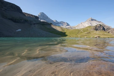
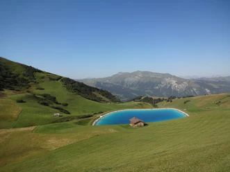
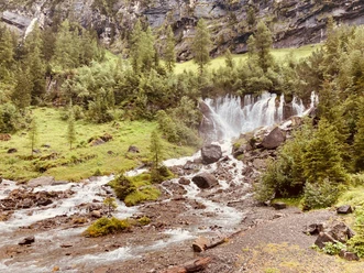
From the Hotel Restaurant Simmenfälle it is only 200 meters to the rapids at the entrance to the forest. A path runs immediately on the left-hand side of the mighty Simme through the forest over roots and rocks upwards. Soon the Barbarabrücke is reached, from where you have a good view of the Simmenfall – considering the splashing spray of the cascading waterfall, hikers will probably quickly cross the narrow but well-secured bridge here. On the other side of the bridge, you reach an alpine road which gently ascends to the beautifully located Alp Rezliberg. From here it is only a short detour to the Sibe Brünne, the source of the Simme. Between Rezliberg and Sibe Brünne, the path branches off to Flueseeli. This runs steeply uphill and is secured with wire ropes in some places. The Fluhsee hut lies to the left; on the right-hand side you can optionally take the approximately half-hour detour to the 2137-meter-high Flueseehöri with a magnificent view of the lake, the surrounding mountains, the Wildstrubel and the Obersimmental. On hot summer days, a swim in Flueseeli provides refreshment after the sweaty ascent. The return journey to the Barbarabrücke is on the same path. Since the outbound route along the Simme to the Barbarabrücke should only be walked uphill, the last section to the starting point is taken on the road.
Background: The source of the Simme is called «Sibe Brünne» (Seven Fountains) because it consists of seven adjacent waterfalls, which gush out as a thirty-meter-wide fan from rock cracks. The cave system of this karst spring originates about one thousand meters higher, where the meltwater from the Plaine Morte glacier sinks into the rock – due to the glacier's water supply, the amount of water gushing from the rock at Sibe Brünne remains almost constant all year round.

Good to know
Pavements
Best to visit
Directions
Equipment
We recommend the following equipment: sturdy mountain boots, medium-sized backpack with hip belt, sun protection, rainwear, hiking poles, first aid kit, picnic, sufficient liquids, mobile phone.
Directions & Parking facilities
Return: by bus from Lenk / Simmenfälle
Additional information
Literature
License (master data)
Author´s Tip / Recommendation of the author
Safety guidelines
Map
Nearby